


Forager's Buddy - GPS foraging
Deskripsi Forager's Buddy - GPS foraging
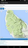
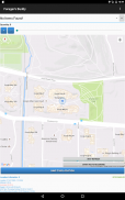
Forager's Buddy adalah aplikasi gratis untuk smartphone dan tablet android, yang dirancang untuk membantu pengguna menandai di peta semua tempat yang luar biasa, di mana mereka dapat menemukan berbagai jenis sumber makanan liar (Menggunakan modul GPS perangkat).
Anda dapat menggunakan aplikasi mencari makan ini dalam berbagai kegiatan di luar ruangan seperti rempah-rempah liar/kumpulan jamur, berburu, memancing, berkemah, hiking, dll
Penting: Android 10+ memiliki setelan izin lokasi baru. Agar perekaman rute Sobat Penjelajah berfungsi dengan baik, Anda harus memilih opsi "Izinkan sepanjang waktu" (dari Info aplikasi -> Izin aplikasi -> Lokasi).
Panduan Referensi Cepat Forager's Buddy [PDF] - https://bit.ly/3usgDt6
Tutorial Cepat Sobat Forager 1 [Video] - https://youtu.be/jWCD6dVO3II
Tutorial Cepat Sobat Forager 2 [Video] - https://youtu.be/s9DHd6lT160
Tutorial Cepat Sobat Forager 3 [Video] - https://youtu.be/2TmSqWIxSC0
Tutorial Cepat Sobat Forager 4 [Video] - https://youtu.be/f-jYRJls89Q
Tutorial Cepat Sobat Forager 5 [Video] - https://youtu.be/Ssx1a3Y-C1I
Jangan ragu untuk memberi tahu kami tentang perubahan yang ingin Anda lihat di Sobat Penjelajah.
Fitur (Edisi gratis):
1. Pemilihan antara unit sistem imperial dan metrik
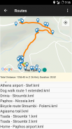
2. Perekaman & tampilan rute (Mengekspor rute sebagai format file .kml)**. Ada kemampuan untuk melihat tempat terdekat dan mengonversi file rute .kml ke format .gpx
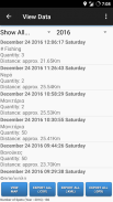
3. Mengekspor dan Mengimpor data sebagai CSV.
4. Penyaringan Data.
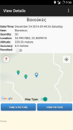
5. Lampirkan foto ke lokasi
6. Melihat perkiraan jarak setiap item dari lokasi pengguna saat ini.
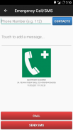
7. Panggilan Darurat dan SMS (Mengirim SMS dengan lokasi terakhir yang diketahui pengguna dan status baterai perangkat).
8. Favorit.
9. Berbagi Lokasi Item (misalnya melalui E-mail atau SMS).
10. Berbagi Lokasi Saat Ini (misalnya melalui E-mail atau SMS).
11. Berbagi file CSV (misalnya melalui E-mail atau Bluetooth).
12. Berbagi file rute KML (misalnya melalui E-mail atau Bluetooth).
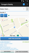
13. Lokasi Kustom. Pengguna dapat menyimpan tempat khusus dari layar utama, dengan mengklik lama pada lokasi yang diinginkan di peta.
14. Auto backup (ekspor ke .csv) setiap kali pengguna melakukan perubahan.
15. Tema gelap
16. Anda dapat dengan mudah menemukan apa yang harus dicari di bulan ini (berdasarkan temuan Anda sebelumnya)
Fitur (edisi Pro):
1. Semua fitur edisi gratis / Bebas iklan
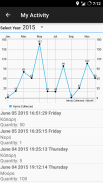
2. Aktivitas Saya. Representasi grafis dari jumlah item yang dikumpulkan setiap bulan.
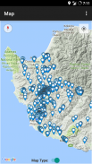
3. Radar. Menampilkan peta dan daftar barang yang dikumpulkan oleh pengguna. Peta diperbarui setiap 3 detik. Jangkauan radar dapat disesuaikan: 0 – 1000 meter.
4. Lokasi Kustom. Pengguna dapat menyimpan tempat khusus dari layar "Lihat Peta", dengan mengklik lama pada lokasi yang diinginkan di peta.
5. Kondisi cuaca saat ini untuk lokasi item saat ini dan yang disimpan.
6. Ekspor data ke format file .kml (Pengguna yang menggunakan alat seperti Google My Maps, dapat menggunakan fitur ini untuk membuat peta khusus untuk situs web atau blog mereka).**
7. Ekspor data ke format file .gpx.
8. Cari Catatan.
9. Buat Pengingat di Kalender.
10. Tampilkan tempat terdekat (di layar Tampilkan detail item).
File yang diekspor oleh Forager's Buddy (.csv, .gpx dan .kml), dapat dengan mudah diimpor dalam Perangkat Lunak GIS (Sistem Informasi Geografis) (seperti QGIS), untuk analisis data geografis lebih lanjut.
Izin:
1. Kontak/Telepon - Untuk fitur "Panggilan Darurat/SMS". Pengguna dapat memilih kontak untuk menelepon atau mengirim SMS jika terjadi situasi darurat (ini juga mengirimkan lokasi terakhir yang diketahui pengguna dan status baterai perangkat)
2. Lokasi - Untuk alasan yang jelas :)
3. Penyimpanan - Untuk menyimpan file yang diekspor seperti: spot (.kml, .csv), rute (.kml) dan foto
Apakah Anda seorang blogger atau jurnalis? Minta Kode Promo Google Play untuk menguji edisi Forager's Buddy PRO! https://goo.gl/ufpt7M
** KML adalah format file yang digunakan untuk menampilkan data geografis di browser Earth seperti Google Earth, Google Maps, dan Google Maps untuk seluler.
Forager's Buddy - GPS foraging - Versi 3.8.2
(02-08-2024)Forager's Buddy - GPS foraging - Informasi APK
Versi APK: 3.8.2Paket: com.gh_its.foragersbuddyVersi Terakhir dari Forager's Buddy - GPS foraging
Versi lain


Aplikasi pada kategori yang sama

Anda juga mungkin suka...
Aplikasi pada kategori yang sama


